
Using GIS for Municipal Asset Mapping and Disaster Preparedness
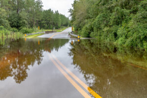
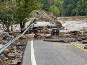
Using GIS for Municipal Asset Mapping and Disaster Preparedness Geographic Information Systems (GIS) are a powerful tool used to capture, store, analyze, and visualize spatial
Small towns are close-knit communities that frequently rely on manual processes to oversee service requests, asset conditions, and asset risk analysis. Often, individuals responsible for
This year, the province of British Columbia is advancing its plan to strengthen its local communities in cooperation with the Canada Community Building Fund by
When it comes to managing municipal infrastructure, two key terms often arise: Geographic Information Systems (GIS) and Asset Management. While they are closely linked, they
Managing encroachment permits can be a complex and time-consuming task for municipalities. Unlike building permits, which typically involve a structured approval process for new construction,
Permitting is an essential step in building sustainable, safe communities. The permitting process is the formal procedure that government agencies and municipalities use to evaluate
While larger municipalities often boast greater resources and staff capacity, smaller communities with populations under 50,000 often face unique challenges in managing building permits, planning
Storms and inclement weather create significant challenges for municipalities, often bringing intense rain, strong winds, flooding, and other destructive forces which can severely impact infrastructure.
In the public sector, Asset Management is often viewed as something that only large cities with big budgets and dedicated departments can effectively implement. Small
Discover how technology is transforming water and wastewater asset management, improving efficiency, reducing costs, and enhancing service delivery.